|
|
本帖最后由 diver18 于 2011-11-18 23:46 编辑
更详细的图在这:http://bbs.m4.cn/thread-3238884-1-1.html
Google Maps Mystery Actually Spy Satellite Targets, Expert Says
By Natalie Wolchover
Published November 17, 2011 | TechMediaNetwork
http://www.foxnews.com/scitech/2011/11/17/mysterious-symbols-in-china-desert-are-spy-satellite-targets-expert-says/


Conspiracy theorists are having a field day with new images from Google Earth showing strange patterns covering miles of Chinese desert.
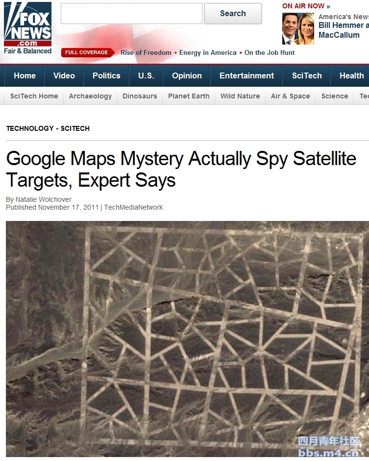
Newfound Google Maps images have revealed an array of mysterious structures and patterns etched into the surface of China's Gobi Desert. The media — from mainstream to fringe — has wildly speculated that they might be Chinese weapons-testing sites, satellite calibration targets, street maps of Washington, D.C., and New York City, or even messages to (or from) aliens.
It turns out that they are almost definitely used to calibrate China's spy satellites.
So says Jonathon Hill, a research technician and mission planner at the Mars Space Flight Facility at Arizona State University, which operates many of the cameras used during NASA's Mars missions. Hill works with images of the Martian surface taken by rovers and satellites, as well as data from Earth-orbiting NASA instruments.
The grids of zigzagging white lines seen in two of the images — the strangest of the various desert structures — are spy satellite calibration targets. Satellite cameras focus on the grids, which measure approximately 0.65 miles wide by 1.15 miles long, and use them to orient themselves in space. [Photos: Mysterious Structures In China's Gobi Desert]
The existence of these calibration targets may seem suspicious or revelatory, but Hill said it really isn't; China was already known to operate spy satellites, and many other countries (including the United States) do so as well. In fact, the U.S. also uses calibration targets. "An example I found just now is a calibration target for the Corona spy satellites, built back in the 1960s, down in Casa Grande, Ariz., [at coordinates] 32° 48' 24.74" N, 111° 43' 21.30" W," Hill told Life's Little Mysteries.
The 65-foot-wide white lines that make up China's grids are not made of reflective metal as many news sites have suggested. "They have gaps in them where they cross little natural drainage channels and the lines themselves are not perfectly filled in, with lots of little streaks and uneven coverage. I think it's safe to say these are some kind of paint," Hill said, noting that if they were made of white dust or chalk, the wind would have caused them to streak visibly.
The calibration targets are larger than might have been expected, he said, suggesting that the satellite cameras they are being used to calibrate have surprisingly poor ground resolution. |
|
